THE BORDERS OF CENTRAL EUROPE: POLISEMIES AND FLEXIBILITIES
The study of borders involves, to begin with, a necessity for focus, of the niche especially because this notion contains very vast factual and linguistic polisemies. În fact, we can approach the problem from a political viewpoint (as a potentially conflictual delimitative space), an economic viewpoint (as a space for exchange), a social viewpoint (as a mark of social lag) or cultural viewpoint (as a variable limit between cultures, customs and daily practices that are more or less anchored in history).
The Romanian language contains a remarkable polysemy when it comes to talking about borders. We can refer to graniţă (border) as a ”natural or conventional line that separates the territory of a state from that of another” (cf. DEX), or border as ”demarcation line between two national entities” (ibid.), but there’s also the more locally-identifiable hotar (boundary), which implies a demarcation limit between two properties. This practical fascination with limits has enriched the linguistic flow by referring to exterior limits (capăt – bottom of, margin – margin, sfârșit – end), as well as centripetal references (miezună, mejdină, mijloc – middle).
Inevitably, the phenomenon of the border is one of limits, approached by man since the first structuring of human society. This fact is a normality, the limit having to do with the need for a space of one’s own that man experiences socially. Therefore, between individual territoriality (ancestral in nature) and actual state territories, the difference is not one of essence but of dimension and formalization (means of control and forms of demarcation). Thus, the spirit of closeness of a territory remains constant, although the limits have always been on a course of cyclic fluctuation of territorial expansion of contraction1.
Regardless of historical period, borders limit and define, unite and separate those from here from those over there, the ones withinfrom the ones without or the ones before from the ones after. These facts lead to the idea that the border is before anything else a geopolitical space. Thus, since Antiquity, the border is an ideal protective factor (think of the borders of Greek city states of theRoman limes). It’s also this fact that has transformed borders into mutual exclusion zones and in conflict fronts. Up until the Middle Ages, borders represented intermediary spaces, usually ones of conflict between entities that wished to ensure a vast contour that would allow for survival and development2. It wasn’t until the 16th-17th centuries that customs systems were generalized, becoming part of inter-state agreements. The case of the Treaty of the Pyrenees (1659) between the families of Bourbon and Habsburg, through which administrative regulations were fixed as well as commercial and military regulations, delineating the watershed of the Pyrinees as a formalized natural border3.
If the long line of military conflicts meant a perpetual tracing of the World’s frontiers, when these were finally loaded with a cultural component, they became more durable. It is, upon first glance, a paradox that a culturally-identitary fact (soft in theory) can leave deeper marks on the world’s maps than a military one (hard). But we can invoke as a first example of tracing milenary boundaries: the territorial configurations that occurred after the Great Schism (1054) that sum up a millennium of cultural, religious and economic differences. Western Europe and Easter Europe traveled, back to back, for centuries ending up in a period of confrontations and finally one of differentiations. Where could we place the Banat inside this historical framework? Certainly, in an inference zone, swingin progressively as a margin of West and East: that of the Kingdom of Hungary, then that of the Ottoman Empire, then that of the Habsburg Empire, Austrian and Austro-Hungarian Empire until it became part of the sphere of oriental Christianity.

Once religious activist in Europe became moderate starting with the last century and a half, the dispute over borders was forged by the elan of national states, build on the old foundations of empires, emerging in the margins of former empires, like for example the case of the interstitia of Austrian, Otoman, Tsarist or German rule (Romania – 1877 and Yugoslavia, Czechoslovakia, Poland – 1918). These structural alterations generated re-centering of these parts of the continent, being subjected to several shapings that could hold all of the above mentioned spaces. There begs the question: ”Where is Europe’s centre? What spaces are included in Central Europe?”. And, in the case of this paper, ”is the Banat part of Central Europe?”
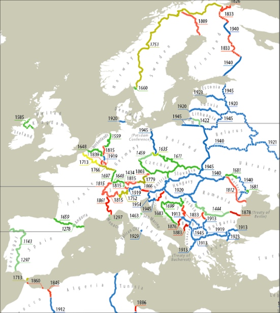
The geonim of Central Europe was coined in the 19th century4 and refers to the space shaped along the ages by the migrations of Germanic and Slavic peoples, generating a geocultural and geopolitical development that shifted the center of gravity of Europe from the Mediterrannean towards the north. The consecutive waves of population transfer from the territories of today’s Germany, Austria and France towards Eastern Europe (Saxons and Swabians) pushed the boundaries of Central Europe ever eastwards, towards the arc of the Carpathians. But the falling apart of empires and then, the fall of the Iron Curtain, have re-traced the geometries of Europe, putting into debate the limits of Central Europe. After the Second World War, and similarly, after the fall of Communism, researchers could not reach a consensus referring to this point (see fig. 1). Some5 take the former empires as reference, tracing the limits of Central Europe up to the Carpathians. Others6 consider the quadrangle of Germany, Poland, Hungary and Switzerland as being more cohesive.
It is clear that the issues had not been resolved, seeing that the former empires continue to fuel present perceptions and representations. Moreover, German speaking geopolitics operated for more than a century using the term ”Middleurope” – Mitteleuropa, which gained strong political and revisionist connotations, when referring to the domination of the center of the continent by the authority in Berlin7. Uninhibited by historic undertones, a new term is gaining traction – Median Europe, which includes a geographically relevant space, starting from Bohemia and Silesia until the Balkans.8
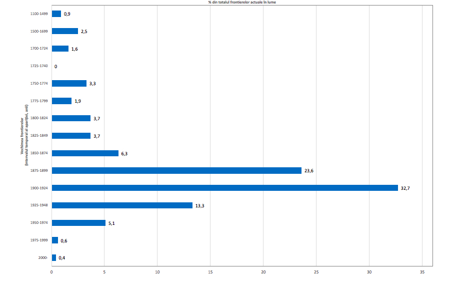
Beyond various word associations mentioned above, it is noteworthy to mention that from the experience of geohistory, no border is immovable9. More than that, 52.1% of the actual borders of the world (summing up the length of 133,206 km) were traced after the year 1900 (see fig.2)!
On average, the oldest borders are european, but these do not include those of Eastern Europe of the Balkans, traced in their majority after the year 1920. The borders of Romania are in this case the exception, through their diversity: if the border with the Danube is one of the oldest on the continent (1444), the border on the Prut river appears in 1812, after the Russo-Turkish War, and that of Dobrogea appears in 1878, after the War for Independence. In other words, on the southern limit of the Banat meet a border from 1444 with one from 1920.
”PHANTOM” BORDERS
The borders of empires in the central-eastern part of Europe were pulverized 100 years ago. Still, similar to ghosts, they appear in sharp focus in the most unexpected moments: when some statistics underline the technical-municipal spacing of buildings in Bukovina compared to surrounding territories, when we receive the electoral differences between western and easter Ukraine, when we analyze the linguistic influences of Magyar/ Serbian/ German in the Banat and Ardeal, or the similarity of ground plans of settlements in the Banat with Croatian Slavonia and not with other parts of Romania.
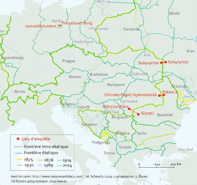
A comparative study focusing on this subject was done inside the project Phantomgrenzen inn Ostmitteleuropa10, aiming to map all potential phantom borders of Europe (fig. 3).
The general remark is the one that phantoms appear as cracks that run through central parts of Poland, Romania and Serbia, having considerable dimensions. The above mentioned examples, randomly, set themselves apart from the simple typology of ethnic or cultural borders, marking rather identitary or group differences that are less connected with territory. The phantom borders take less account of ethnic differentiation, focusing on different practices based on the way of a deep embedding in the territory48.
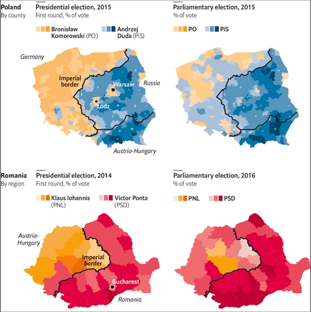
It’s clear we are talking about old spacial continuities that continue to transcend actual borders. These continuities are transposed into mental collectives of a regional nature, fact proven clearly through election maps. Recurring cases happen in Romania, where the Carpathians still represent a considerable mental barrier, but also in Poland where the interstitium of three empires is visible (fig. 4). As a conclusion, one has to remind of mental geographies anchor in defunct realities that can generate moment of instability for national states in the current matrix, so much so when talking about countries were cohesion politics does not work at optimal levels and in which inter-regional lags are getting larger.
THE WEST OF TIMIȘ COUNTY: A BORDER GRADATION
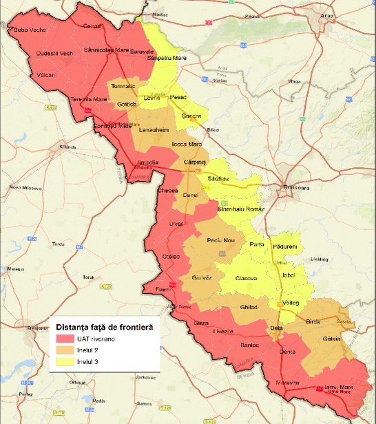
Observations in the field undertaken in the period July-September 2019 brought with them the hypothesis of a progressive gradation in the element of socio-spatial elements starting from the center of Timiș country, towards its western border. Quality surveys in the field confirmed this fact. In view of this, we shall test the hypothesis from a statistical standpoint. We have divided the territorial-administrative units along the border in three parallel lines: ring 1 – TAU on the border side (in red in Fig. 5), and rings 2 and 3 respectively (in orange and yellow).
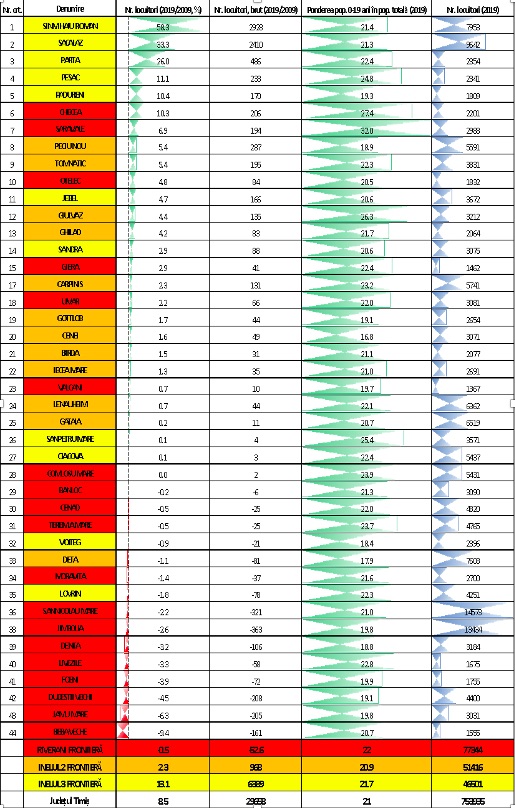
A first observation is that in the immediate vicinity of the border there are 77,344 inhabitants in 17 localities plus the cities of Jimbolia and Sânnicolau Mare. At the same time, the ratio of young population (0-19 years of age) is superior to the average of Timiș county (21%) as well as that of the administrative center of Timișoara (16%) and also that of the 2 complementary rings (20.9% and 20.7%). This fact can be explained by a high birth rate in the localities Saravale (32% – first in the county), Checea, Giulvăz and Sânpetru Mare (all over 25%).
Although the ratio of young people is high close to the border, this indicator alone is not sufficient to explain in-depth socio-territorial dynamics. Therefore, if in the last 10 years the localities situated in the third ring around the border have gained 6,389 inhabitants, and those on the second ring have gained offer 1,000, this indicator is negative close to the border (-0.5% in the last 10 years).
A solution to this decline is linked to the developing of axis of matter and energy that perpendicularly penetrate the borders: Timișoara – Lovrin – Cenad, Timișoara – Cărpiniș – Jimbolia and Timișoara – Deta – Moravița. A development of these can offer the border a higher rate of porosity, placing communities along the border in a position that would be less marginal from an economic perspective. Basically, this space is dependant on the capacity of Timișoara to re-tale the classic links of the western Banat hinterland, but also on the development of relationships of exchange with medium (Novi Sad, Szeged) and major actors (Budapest and Belgrade). The way in which these potentialities will be developed shall influence the state of border communities: re-centering them or, on the contrary, marginalising them.
Annex
LIVING SPACES. BETWEEN REPULSION AND IDEALIZATION.
During the interviews I noticed the diversity of places evoked by the interviewed persons. Whether the story started with the place of birth, or the places of origin of the spouses, neighbors, friends, etc., or the deportations, schooling or jobs were discussed, the spaces lived, perceived and conceived became a central motive in the analysis.
From a methodological point of view, we have extracted from each interview each mentioned place / locality / region and granted it two types of attributes. The first refers to the feeling in which the interviewee places the place (positive, negative or neutral), and the second describes in a few words the story related to that place.
The database created after the 10 interviews (5 in Lenauheim, 2 in Comloșu Mare, 2 in Comloșu Mic and 1 in Beba Veche) contains no less than 402 places mentioned. These were classified into 8 maps as follows:
・The first three maps refer to the incidence of localities evoked by the interviewees. The first observation is related to their remarkable diversity. If Timișoara (as a regional pole) and Jimbolia (as a local pole) stand out, they are added to many localities in the living space (surrounding communes, fair villages, work places, going to school, etc., map 1). However, truly remarkable is the diversity of places in the country and abroad evoked or even crossed / inhabited by the respondents. There are two categories in the country (map 2): places of origin (Banat) and places of deportation (Bărăganul). To these are added numerous localities from abroad (map 3). The most remote are on the American continent, where the grandparents of the interviewees worked. Then comes Central Europe (where some took refuge during World War II or later migrated) and Russian space (deportations)
・If the living space is a sum of positive and negative experiences (map 4), on another scale the general tendency is that of a West-East degradation (maps 5 and 6), where the West appears idealised (as a place of refuge, emigration, developed , of course), and the repulsive East (deportation bargain, Russian concentration camps or the lost Cadrilater).
We chose to make two maps of life, which illustrate an unusual aspect:
・Map 7 shows the life of Mrs. N.P. from Comloșu Mic, who is born in Bulgaria (Cadrilater). After the loss of this region by Romania, the family with 5 children takes refuge in Brăila, then in Chișinau, then in Maglavit, finally settling in Banat. After the father’s return from the war, new challenges arise: collectivization and especially deportation to Bărăgan. Returning from there causes new suffering: losing the house, building another.
・Map 8 depicts the life of Mr. A.M. from Lenauheim, who tells us about his grandparents going to work in America, then about his uncle deported to the Crimeea, about his neighbors deported to Bărăgan and Bessarabia, but also about his personal flight itinerary to Germany at the end of the war. Life goes on with a series of struggles between Germany and Romania, with departures to work, football games, mayor’s office or children’s emigration.


[1] Nicolae Popa, Frontiere, regiuni transfrontaliere și dezvoltare regională în Europa Mediană Ed. Universității de Vest, 2006.
[2] Amadeo Lopez, La notion de frontière, America. Cahiers du CRICCAL, 1993, pp. 7-20.
[3] Daniel Séré, La paix des Pyrénées: vingt-quatre ans de négociations entre la France et l’Espagne, Honoré Champion, p. 607.
[4] Nicolae Popa, op. cit., p. 22.
[5] Lonnie Johnson, Central Europe: Enemies, Neighbors, Friends, Oxford, Oxford University Press, 2011; Czesław Miłosz, Une autre Europe, Paris, Gallimard, 1964; Peter Jordan, Large-scale structuring of Europe according to cultural space criteria, SSOAR, 2005, pp. 162-173.
[6] Georges Castellan, Histoire des peuples de l’Europe centrale, Fayard, 1994; CIA Factbook.
[7] Yaël Hirsch, Nostalgie de la Mitteleuropa et engagement politique. Vies et destins de trois poètes déracinés: Else Lasker-Schüler, Benjamin Fondane, et Czeslaw Milosz, Raisons politiques, 1-41, 2011, pp. 121-139.
[8] Michel Foucher, Fragments d’Europe, Fayard, 1993.
[9] Frédéric Encel, Mon dictionnaire géopolitique, Presse Universitaire de France, 2017, p. 500.
[10] Béatrice von Hirschhausen, De l’intérêt heuristique du concept de «fantôme géographique» pour penser les régionalisations culturelles, L’Espace Géographique, 2017, 42, 106-125.
This study was originally published in the MOVING FIREPLACES. 2019 book.
Photo credit: Diana Bilec
Leave a Reply